

Interoperability and the Value of Standards
Edición: Vol.3 Núm.1 enero-abril 2012

|
This article provides a discussion about Interoperability and the Value of Standards. It describes the Open Geospatial Consortium (OGC) and standards developed by OGC working groups. The standards presented are commonly used in Spatial Data Infrastructures (SDIs). The paper also defines Spatial Data Infrastructure, explaining how value is derived from using standards in global projects and SDIs around the world. |
Este artículo ofrece una discusión acerca de la interoperabilidad y el valor de los estándares. Se describe el Open Geospatial Consortium (OGC) y las normas elaboradas por los grupos de trabajo del OGC. Las normas presentadas son las que comúnmente se utilizan en las infraestructuras de datos espaciales (IDE). El documento también define la infraestructura de datos espaciales, explicando cómo se deriva valor del uso de estándares en proyectos globales y en las IDE de todo el mundo.
|
1 Introduction
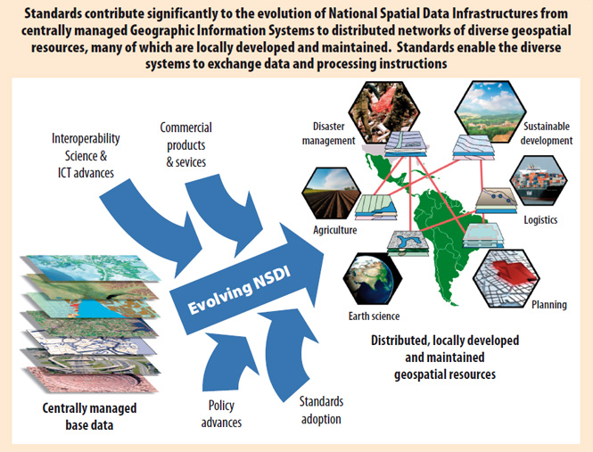
Spatial Data Infrastructure (SDI) is generally defined as the collection of technologies, policies and institutional agreements that facilitate the availability of and access to spatial data. The SDI provides a basis for spatial data discovery, evaluation, and usage for users and providers within all levels of government, the commercial sector, the non-profit sector, academia, and by citizens in general (GSDI 2009).
Geospatial data is crucial for a wide variety of government and private sector activities because it helps provide context for analysis, planning and decision support. After being struck by a natural disaster, for example, a region not only needs current and complete data (such as maps of roads, buildings that can serve as shelters, and places to land helicopters) it also needs to update maps and make them available as fast as possible for response and recovery operations. Unfortunately, geospatial data publishing is done by numerous participants whose information systems use various different formats and protocols, and in the past this made it difficult to access, integrate and use the data. Government agencies, communities and research institutions rely on both off-the-shelf and custom-made software products that often do not interoperate seamlessly.
Fortunately, providers of these software products, following the trend in the larger information technology (IT) world, are moving rapidly toward ubiquitous use of internationally accepted open interface and encoding standards that enable interoperability. Interoperability between diverse distributed systems makes possible more options in procurement and more options in SDI policy.
The OGC is a standards development organization (SDO) focused on providing such geospatial interface and encoding standards. This article provides information, about the OGC, exemplar projects, the value of standards and the importance of OGC and standards in Spatial Data Infrastructures. As more offices in government and businesses in the private sector begin producing and hosting data and as the open standards-based Web becomes the dominant delivery mechanism, Spatial Data Infrastructures (SDIs) become increasingly valuable to governments, citizens and commercial enterprises at all levels.
Figura 1
2 The Open Geospatial Consortium
2.1 OGC Overview
The Open Geospatial Consortium (OGC) is a nonprofit, international, voluntary consensus standards organization, founded in 1994. The OGC leads the development of standards for geographic content and services, sensor webs, and location services. The OGC's mission is to help realize the full societal, economic and scientific benefits of integrating electronic location resources into commercial and institutional processes worldwide. The OGC manages a process in which developers and users of spatial data products and services collaborate to develop and promote international standards for geospatial interoperability. In October 2011 the OGC membership consists of more than 435 geospatial technology software vendors, systems integrators, government agencies and universities.
The primary product of the OGC is "standards". An OGC standard is a document that details the engineering aspects and rules for implementing an interface or encoding that solves a specific geospatial interoperability problem. In a formal consensus process, the contents of standards documents are defined, discussed, tested, and approved by the members. The standards are designed to support interoperable solutions that "geo-enable" the Web, wireless and location-based services, and mainstream IT. They empower technology developers to make complex spatial information and services accessible and useful to all kinds of applications. As of October 2011, more than 40 standards have been published by OGC.
The OGC is not the only SDO. Other SDOs specialize in domains other than geospatial technology. The OGC collaborates with them, reusing their technology and helping address their requirements for location. These SDOs include such organizations as the International Organization for Standardization (ISO) Technical Committee 211, the Organization for the Advancement of Structured Information Standards (OASIS), the Internet Engineering Task Force (IETF) GeoPriv Working Group, National Emergency Number Association Next Generation 911 (NENA), the Open Mobile Alliance (OMA) and the World Wide Web Consortium (W3C).
The OGC also has partnerships with other organizations, such as the Global Spatial Data Infrastructure (GSDI) Association, whose members have an interest in sharing geospatial resources.
2.2. OGC Reference Model
The OGC Reference Model (ORM) describes the OGC Standards Baseline and explains relationships between OGC standards and standards from other SDOs (Percivall, Reed et al. 2008). The OGC Standards Baseline consists of the approved OGC Abstract and Implementation Standards. These include interface, encoding, profile, application schema, and best practice standards.
When developing a standard it is important to avoid dependencies on technologies that could become obsolete in the near future. For this reason, the OGC membership usually begins by developing reference architectures that provide abstract elements of a domain independent of the technologies, protocols and products that are used to implement domain solutions (OASIS Committee Specification 2011). The OGC makes use of the ISO Reference Model for Open Distributed Processing (RM-ODP) (ISO/IEC1998) which provides a useful guide for technology neutral development. The RM-ODP recommends careful documentation of requirements from several view points, such as:
1. The enterprise viewpoint focuses on the purpose, scope and policies of the systems, based on the business requirements.
2. The information viewpoint focuses on the semantics of the information managed by the system and the structure and content type of the supporting data.
3. The computational viewpoint focuses on the functionality provided by the system and its functional decomposition, by defining objects and their interaction through interfaces.
2.3 OGC standards
OGC Web Service standards follow the definition of a Web service originally proposed by IBM, Motorola and others (Vasudevan 2001).
Web Services are self-contained, self-describing, modular applications that can be published, located, and invoked across the Web. Web services perform functions, which can be anything from simple requests to complicated business processes. Once a Web service is deployed, other applications (and other Web services) can discover and invoke the deployed service.
A service is a set of interfaces with a particular functionality provided by an entity (ISO 2005). An interface is a named set of operations that characterize the behavior of an entity (ISO 2005). An operation is a specification of a transformation or query that a service may be called to execute (ISO 2005). An encondig, usually what the service returns, is data converted into code, such as XML (ISO 2011).
When OGC standards are implemented in products or on line services by two different software engineers working independently, the resulting components plug and play, that is, they work together without further debugging.
The SDI Cookbook (GSDI 2009) summarizes the OGC service framework, and categorizes the services by purpose or functionality. It distinguishes the following main types of component services:
• Application Services which are specific applications for each domain.
• Catalog Services to help discover for example resources including services, data, vocabularies, and styles.
• Encodings that provide the code representation for example for data, styles, transformation.
• Data services that provide access to data (e.g. WFS and WMS).
• Portrayal Services that provide services for styling data (e.g. lines and points on a map).
• Processing Services that allow developers or users to create workflows to create complex products and help automate and share processes such as geocoding and coordinate transformation.
A few of the most widely implemented OGC standards are described below:
• Web Map Service: The OGC Web Map Service (WMS) Interface Standard was the first OGC Web service standard. WMS provides the standard interface that allows any browser-based application to access and display geographic content from multiple distributed geospatial repositories where the content is typically stored in a variety of formats and structures. WMS-produced maps are generally rendered in a pictorial format such as PNG, GIF or JPEG, or occasionally as vector-based graphical elements in Scalable Vector Graphics (SVG) or Web Computer Graphics Metafile Vector Graphics (WebCGM) formats. Some image formats support transparent backgrounds (e.g., GIF or PNG) that allow underlying maps to be visible. This allows clients to request maps from different servers, which enables clients to build customize maps from a network of distributed map servers. The first version of the WMS standard was approved in 1999. The most recent version was approved as an OGC standard in 2006 (OGC) and it is also available as an ISO standard (ISO 19128:2005) (ISO 2005). There are currently thousands of WMS implementations providing access to over 500,000 map layers (Reed 2010).
• Web Feature Service: The OGC Web Feature Service (WFS) Interface Standard (OGC 2007) allows a client to retrieve and update geospatial data encoded in Geography Markup Language (GML) (OGC 2007). WFS defines an HTTP based interface for a data access service that enables features from multiple vector (feature) repositories to be queried and managed. The standard defines operations that enable clients to: Discover which feature collections the service offers; get a description of the properties of features; query a collection for a subset of features that satisfy some filter expression; lock a subset of features; and execute transactions against feature collections (Transaction) that allow a client to create new features (Insert), modify existing features (Update) and delete feature (Delete). The mandatory encoding for input and output is GML. However, the standard is extensible and allows for other feature encodings to be supported, such as Geo RSS (Geo RSS) and KML (OGC 2008). WFS is also an ISO standard – ISO 19142:2010.
• Geography Markup Language: The OGC Geography Markup Language (GML) Encoding Standard (OGC 2007) defines a data encoding in XML for geographic data and a grammar to express models of such data using XML Schema. GML provides a means of encoding geographic information for both data transport and data storage, especially in a Web context. GML is extensible, supporting a wide variety of spatial tasks, from portrayal to analysis. It separates content from presentation (graphic or otherwise), and permits easy integration of spatial and non-spatial data. Clients and servers with interfaces that implement the OGC WFS interface read and write GML data. GML is also an ISO standard (ISO 2007). GML contains a rich set of primitives that are used to build application specific schemas or application languages. These primitives include: Feature, Geometry, Coordinate Reference System, Time, Dynamic feature, Coverage (including geographic images), Unit of measure, and Map presentation styling rules. GML enables information communities to define application schemas of GML that capture the information models required for interoperability in their respective communities. There are currently more than 30 GML application schemas across multiple communities (For examples, see http://www.ogcnetwork.net/node/210).
• KML: The OGC KML Encoding Standard (OGC 2008) is an XML grammar used to encode and transport representations of geographic data for display in an earth browser. As such, KML is a language focused on geographic visualization, including annotation of maps and images. Geographic visualization includes not only the presentation of graphical data on the globe, but also the control of the user's navigation in the sense of where to go and where to look. KML, uses a tag-based structure with nested elements and attributes and is based on the XML, standard. From this perspective, KML is complementary to most of the key existing OGC standards including GML, WFS and WMS, KML 2.2 utilizes geometry elements derived from GML 2.1.2. These elements include point, line string, linear ring, and polygon. Google submitted KML (formerly Keyhole Markup Language) to the OGC in 2008 to be evolved within the OGC consensus process with the goal of making KML Version 2.2 an adopted OGC implantation standard. Future versions may be harmonized with relevant OGC standards that comprise the OGC standards baseline.
As of October 2011 there are 35 adopted OGC standards. They enable geospatial interoperability in areas such as:
• Sensor webs.
• SMS (short message service implemented in ordinary cell phones).
• Portrayal systems that display geoespatial data differently for different user communities.
• Web mapping.
• Integration of tabular data (as in spreadsheets) into geospatial systems.
• GIS-to-GIS communication.
• Data fusion.
• Chaining of scientific models.
• Controlling access to geospatial resources.
• Integrating GIS with complex hydrological and meteorological systems.
Briefly stated, OGC standards are making geospatial information an integral part of the world's information infrastructure. If there were no organization like the OGC working toward this goal, the inherent complexity of geospatial information and geoprocessing would perpetuate the reality of geospatial information being locked up in expensive proprietary systems.
3 Exemplar Projects
Geospatial "communities of interest", whether the communities span small geographic areas or the whole Earth, benefit in many ways from adopting OGC standards because these standards make it much easier to share geospatial data and processing resources. That is, they make it easier to publish, discover, assess, access and combine geospatial data and geoprocessing resources available from multiplesources in multiple locations. Two examples are showcased in this section: the Geology Community and the GEOSS (Global Earth Observation System of Systems) community, an international team developing a global architecture to share Earth Observation (EO) data.
3.1 The Geology Community's One Geology
The international geology community has come together in a global project (One Geology) that successfully produced the first online digital geological map of the world. As of October 2011, 117 countries are participating.
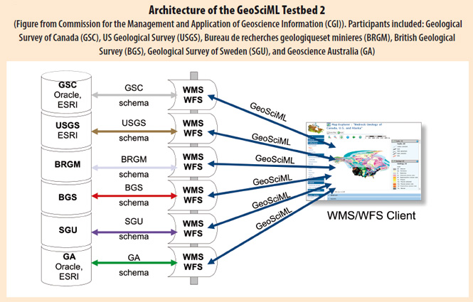
One Geology is underpinned by GeoSciML, WMS and WFS. GeoSciML is an encoding standard developed by the Interoperability Working Group of the International Union of Geological Sciences (IUGS) Commission for the Management and Application of Geoscience Information. GeoSciML is a GML application schema. Implementations of the OGC WMS standard provide access to the geological maps and access to the geological data that is returned in GeoSciML.
Figure 2 depicts the participants in a GeoSciML Testbed. Each participant stores their data in their own database, using their own schema, data model and semantics. They agree to use WMS and WFS interfaces and GeoSciML as the encoding standards to allow GML clients to access and integrate the data seamlessly.
Figura 2
3.2 GEOSS Architecture Implementation Pilot
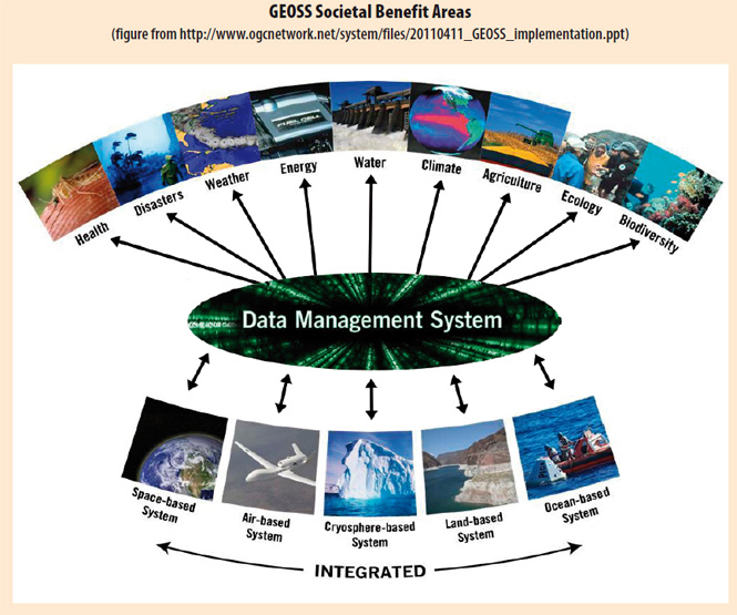
GEOSS (Global Earth Observation System of Systems) is a program of the Group on Earth Observations (GEO), a partnership of 124 governments and international organizations. The ongoing GEOSS Architecture Implementation Pilot (AIP) (Group on Earth Observations 2010), led by the OGC, leads the incorporation into GEOSS of contributed components consistent with the GEOSS Architecture using a GEO Web Portal and a Clearinghouse search facility. The GEO Web Portal and Clearinghouse provide access to services through GEOSS "Interoperability Arrangements" in support of the nine GEOSS Societal Benefit Areas shown in Figure 3 below.
Figura 3
Interpoerability Arrangements consist of policy agreements and online data and processing resources that have been set up based on shared, open standards. These arrangements enable continuous monitoring of the Earth and access to a vast shared set of information resources. Results of the AIP will be transitioned to GEO Task AR-07-01 (Persistent Operations) and the GEOSS Common Infrastructure.
Many science problems are multidisciplinary, use a variety of sensors and require community agreements on standards, such as those provided by GEOSS. For example, ocean scientists need to fuse stored and real-time data from in situ and satelliteborne sensors and traditional digital maps to create useful information. Such information contributes to enhanced policy decisions in areas such as marine ecosystem research, surge flood warning, and climate monitoring. The cost-efectiveness of data collection and software development is multiplied many times when many researchers have a standards framework that enables them to easily share sensors, sensor observations and processing resources. Data collection can be planned cooperatively, reducing redundant collection efforts and improving the return on funding agencies' investments. Sensor accuracy can be cross-checked more easily. Catalogued data and metadata, in agreed encodings and formats and available on line, enable faster and more accurate data fusion. Web services for data reduction or analysis can be used by multiple organizations, and computational models can be chained with less effort and better quality assurance.
4 Value of Using Standards
OGC members including business, government and academic organizations join the OGC for business reasons. Typically, government executives, research managers, senior sales and marketing profesionals or department heads make the decision to join the OGC and participate in OGC activities. Why? They see in the OGC unique opportunities for learning about the state of the art with regard to interoperability, standards, and applications that implement OGC standards. They also see value in collaborating with their peers in exchanging knowledge across communities of practice. They understand that using standards saves time, money, energy, and sometimes, lives. In addition, government and business leaders understand that influencing and using standards contributes to national economic health.
The OGC Business Value Committee (BVC) engages senior managers and sales and marketing professionals from the OGC membership in activities to identify, organize and promote the business value of OGC standards. The Business Value Committee email list is open to both members and nonmembers.
Organizational needs and agendas drive progress toward interoperability and technology convergence. Different communities of interest have different but overlapping needs and agendas, and often these communities must share information. The OGC consensus process provides members numerous opportunities to express interoperability requirements and work together to shape the OGC standards to meet those requirements. Members take advantage of both the standards and the partnership opportunities to "connect the dots" between different information systems and application domains. The key value of technical interoperability is that it facilitates organizational cooperation and effectiveness. Implementing OGC standards facilitates data sharing, while participating in OGC activies facilitates multi-community and cross-domain cooperation.
Much of the OGC standards work begins in OGC Interoperability Program (IP) test beds, pilot projects and interoperability experiments. In these rapid prototyping activities, each sponsor's investment is leveraged by the investment of other sponsors as well as in-kind participation by other OGC members, thereby reducing each sponsor's share of the initiative´s cost and increasing the return on each sponsor´s investment. The ratio of contributions by one sponsor of OGC initiatives to contributions by other organizations is typically between 1:1 and 1:4.
Besides the levarage of cost-sharing, there is the further leverage that results from more soponsors attracting more technology provider participants. Technology providers contribute significant resources to develop, test, and demonstrate the ability of emerging or existing OGC standards to address sponsors' interoperability requirements. When there are more sponsors and more technology "threads" involved in an OGC interoperability initiative, there is more incentive for technology providers to get involved.
For sponsors, a key attraction of the Interoperability Program is the increased ability to integrate systems and protect technology investments at a cost that is much lower than the cost of one-off integration projects that use custom interfaces and encodings. These savings come first to sponsors and later to non-member stakeholders around the world.
OGC membership offers an excellent way for governments to work with industry and academia to stimulate economic activity. Open interfaces and encodings generated from OGC initiatives often spark new business successes, which aggregate into regional and national competitive advantage. New and more affordable products and services bring commerce, profit, employment and increased innovation. European public and private sector organizations, for example, have played key roles in the OGC, and European membership now exceeds North American membership. In Europe, there has been remarkable innovation in areas such as urban 3D models, sensor webs and Internet security involving online spatial resources. The OGC Open GeoSMS Standard introduced into the OGC by an organization in Chinese Taipei is resulting in significant business activity there and elsewhere. Small businesses and business units in larger companies employ many people in business activities resulting from such innovation.
Business activity like this delivers the value of open standards to governments working to build SDIs. The OGC's work in sensor webs, geospatial rights management, service chaining, geosemantics, data quality and other areas helps companies provide value and helps governments provide better services at lower cost. Cost savings through increased interoperability and broad implementation of OGC standards in products lead to wider general use of GIS and other spatial tecnologies. This increases the base of users for Spatial Data Infrastructure, and these users are using the infrastructure to do things that have economic and societal value.
5 Spatial Data Infrastructures and the value of standards
OGC standards as well as complementary ISO standards have become part of SDI "best practices" around the world. Standards lower costs and decrease the time required for systems integration. With wide use of standards-based Web services, "loose coupling" between systems becomes possible. That is, developers of such systems don't need to know details about other systems that their systems might interoperate with. They only need to know that they have correctly implemented certain standards and that other systems are available that have also correctly implemented the standards.
5.1 Countries and regions using OGC standards in SDIs
• Abu Dhabi – The Abu Dhabi Systems and Information Centre has engaged most of the emirate's government entities and federal entities within the Abu Dhabi NSDI (AD-SDI) to support sharing of geospatial information and services. The AD-SDI uses ISO and OGC standards.
• Australia – The Australian SDI consists of a framework of guidelines (including the practice of using open standards, from OGC and other) and policies developed by ANZLIC - the Australian and New Zealand Land Information Council. The Australian SDI also comprises capabilities at state and territory level such as the western Australian (WA) Government's Shared land Information Platform (SLIP), wich forms the foundation of an information connection service that serves 19 WA government agencies and the New South Wales Government's Spatial Information eXchange (SIX).
• Brazil – The legal framework provided by the National Spatial Data Infrastructure (INDE) establishes that the production of data and geospatial information must follow standards and regulations accredited by National Commission on Cartography (CONCAR). The Brazilian Institute of Geography and Statistics (IBGE) and CONCAR recently made available the INDE Geoportal, also called SIGBrasil that integrates geospatial information from different institutions. Initially the portal will integrate federal data and in the coming years will integrate other data such as the ones provide by the municipalities. The portal supports services following OGC specifications such as WMS, CSW and WFS.
• Canada – The Canadian Geospatial Data Infrastructure (CGDI) includes the Canadian government provinces, territories and the private sector. The CGDI is a distributed network of spatial data and processing resources that gives decision- makers access to online location-based information, offering valuable benefits to decision- makers in priority areas such has public safety, public health, Aboriginal community planning and environmental management. Example of data available via OGC standards includes data from the Canadian Council of Forest Ministers National Fo-rest Information System (CCFM NFIS) and the Canadian Geospatial Data Infrastructure Road Network.
• Chile – The Government of Chile, through the National System of Territorial Information Coordination (SNIT in its Spanish acronym), is promoting activities and fostering the use of technologies enabling the integration of geospatial information through Web services. SNIT provides services following OGC specifications such as WMS, CSW and WFS (e.g. "Geoportal of Chile" and "Geonodo").
• China – The China Ministry of Land and Resources is using applications based on the OGC WFS to build a country-level and proprovince- level data exchange system that satisfies update requirements for land use data.
• Colombia – The first country in South America to develop an SDI was Colombia. Work on the Colombian Infrastructure of Spatial Data (ICDE) started in 1996. The Columbian National Committee on Normalization of Geographic Information has adopted geospatial standards from ISO and OGC for use in the government's geospatial portal (ICDE portal), metadata registries (SWAMI tool) and web services. By using standards, agencies have been able to provide different types of data to the ICDE portal, including data about biodiversity, hydrology, mining and energy, transportation, education, and the marine and coffee industries.
• European Union – Most of the SDIs in Europe follow the Infrastructure for Spatial Information in Europe (INSPIRE) Directive. All EU Member States have now transposed the INSPIRE regulations into national law. The Directive leverages a standards-based architecture to promote geospatial interoperability across the EU.
• Germany – The GDI-DE. The German SDI provides more than 2000 layers from 70 OGC WMS services, enabling federal state agencies, municipal authorities and private companies to share their data.
• Great Britain – Ordnance Survey Great Britain became involved in OGC standards early in 2000 to structure and deliver their products using open standards. Today they deliver Ordnance Survey products through WMS. This includes the large scale OS MasterMap Topography Layer, which is in a raster format that is dynamically generated from the vector data store. The UK Location Programme also explicitly mentions OGC standards, for example, in their "Initial Guidance to Data Providers and Publishers - Guide 4: Publishing Discovery and View Services".
• The Netherlands - The Dutch Geo-Information and ICT Department of Rijkwaterstaat (the Ministry of Transport, Public Works and Water Management) has an SDI based on open standards. The Ministry's responsibilities include traffic via roads, waterways, railways, and by air, and they are also responsible for clean water in the rivers, lakes, sea, and water tables. The Dutch National Mapping Agency Kadaster uses a GML-based application schema for data sharing. The Dutch Kadaster Topographical Service has demonstrated interoperability involving their TOP 10 GML shemas (also known as TOP1ONL) and a number of commercial products. Geonovum's 3D Pilot NL is the first comprehensive national effort to use the OGC CityGML Encoding Standard as the basis for urban asset management, data integration and visualization.
• Norway – "NorgeDigitalt" (Digital Norway) is the Norwegian government's initiative to build a national geographical infrastructure. Since 2005 more than 100 operational web map services, geoportal and other services have been in coexistence. Information dissemination is done via OGC WMS where downloadable data are made available via standard formats; metadata is delivered together with the data. Using ISO and OGC standards the national portal provides information regarding the status of the available data and web map services.
• Spain – IDEC, the Geoportal of the government of the autonomous region of Catalonia, offers several servicies, including the multilingual Catalog Server describing data available from over 80 providers. The Viewer, a client that implements the VMS, allows users to access more than 200 layers of geodata. A 2007 study by the Centre of Land Policy and Valuations of the Universitat Politècnica de Catalunya showed that the initial investment to set up the IDEC SDI was recovered in just 4 months, or 6 months if the operating costs for 2004-05 were also included (Garcia Almirall, Montse Moix et al. 2008).
• USA – Many US federal agencies use systems that implement OGC standards. The National Climate Data Center Portal (NCDC), for example, the world's largest active archive of weather data, uses WMS and WFS interfaces to provide access to numerous climatological and meteorological resources. The National Oceanographic and Atmospheric Administration's (NOAA) Integrated Ocean Observation System (IOOS) links together a wealth of ocean observation data from a wide variety of federal and non-federal sources through the use of OGC standards. A growing number of US states have built or are building Web-centric SDIs that rely on OGC standards. NGAC recently released a Best Practices paper to help local governments with their own SDIs (National Geospatial Advisory Committee 2011.
5.2 SDIs for local and subnational governments
Many local and state or provincial government agencies and offices worldwide face similar challenges involving planning and providing services for growing populations in an era of serious financial constraints and shortages of resources such as water and fuel. At the same time, many regions are beginning to experience weather – related difficulties that seem likely to worsen as climates change.
All such organizations would like to maximize the value they receive from their investments in geospatial information and related technology. The OGC GovFuture membership program helps decision-makers in local and subnational governments understand open standards and use them to best advantage.
Vendors' implementations of the OGC's technical interoperability standards make it technically easy to integrate simple and complex geographic information from almost any source, but technical interoperability alone is not the whole solution. GovFuture provides a forum for knowledge transfer leading to "organizational interoperability. "Gov Future helps local and sub-national governments:
• Address fiscal constraints, sustainability, and the need for improved communication across government jurisdictions.
• Maximize return on past, present and future technology and information investments.
• >See how location technologies are converging -through open standards- with other digital technologies to help cities manage transportation, water supply, sanitation, public safety, public health, zoning, energy, growth and economic development.
• Learn how other localities deal with procurement policies, data quality, privacy, public release of information, information reuse and calls for more open, efficient and effective governance.
• Access vendor resources, guidance from peers, and open source options.
• >Learn how to explain the value of standards to get support for standards strategies.
Explaining the value of standards is important, because developing an SDI requires cooperation. The whole idea of an SDI is to make it easy for many different entities to share geospatial information, and this requires those entities to share some of the same values. GovFuture membership helps government officials explain the business value of SDIs to foster support and implementation. The central message is that SDIs support government activities in everything from disaster and risk management to emergency response and municipal operations. Geospatial information has different values, however, for citizens, consumers, businesses, and different government offices and agencies, and thus SDI "marketing" requires some skill. SDIs depend on interoperability, so the "call to action" is "deploy products and services that interoperate through open standards".
6 Conclusions
As the list of national SDIs above indicates, nations are moving rapidly toward ubiquitous use of internationally accepted open standards. To help organizations advance toward their SDI objectives, the OGC provides an evolving forum and growing offering of tools and processes. In addition to the GovFuture program, the OGC helps members form regional forums, such as the France Forum, ILAF (Iberian and Latin-American Forum), India Forum and Korea Forum. The goals and objectives of OGC's regional organizations differ as necessary to meet the particular needs and circumstances in their regions. But in general they seek to promote OGC membership, coordinate regional participation in the OGC, and promote policies, co-operative business development initiatives and public/ private partnerships that support the use of OGC standards.
The use of OGC standards in Spatial Data Infrastructures is not new. Its value has been proven in many countries worldwide. The OGC is a standards organization, but it is also a hub for transferring knowledge about SDI-related activities. Just as the value of a digital network grows as the number of nodes increases, the value of a knowledge network grows with the number of networked organizations and individuals. Each world region that begins to engage in organized SDI efforts has particular regional circumstances and requirements, but much of what has been learned and developed previously in other places can be reused and shaped to meet regional needs. The exchange of value is reciprocal. Just as OGC members in Europe, Australia and Chinese Taipei have advanced new OGC standards of value to members in all other regions, regions that are currently under-represented in the OGC, such as Latin American, can be expected to make contributions in the future that will have global value.
![]()
References
García Almirall, P., B. Montse Moix, et al (2008). The Socio-Economic Impact of the Spatial Data Infrastructure of Catalonia.
http://www.geoportalidec.net/geoportal/eng/documents/impct_study_report.MAX.pdf
GeoRSS. http://georss.org/Main_Page
Group on Earth Observations (2010). GEO 2009-2011 WORK PLAN. http://www.earthobservations.org/documents/work plan/geo_wp0911_rev3_101208.pdf
GSDI (2009) Spatial Data Infrastructure Cookbook. http://memberservices.gsdi.org/files/?artifact_id=655
ISO (2005). Geographic information – Web map server interface. http://www.iso.org/iso/iso_catalogue/catalogue_tc/catalogue_detail.htm?csnumber=32546
ISO (2005). Geographic information – Services. International Organization for Standards. http://www.iso.org/iso/iso_catalogue/catalogue_tc/catalogue_detail.htm?csnumber=39890
ISO ISO 19136:2007 (2007). Geographic information – Geography Markup Language (GML). http://www.iso.org/iso/iso_catalogue/catalogue_tc/catalogue_detail.htm?csnumber=32554
ISO (2011), ISO/TC 211 Glossary of Terms – English.
ISO/IEC (1998). Information technology – Open Distributed Processing – Reference model: Overview. http://www.iso.org/iso/iso_catalogue/catalogue_tc/catalogue_detail.htm?csnumber=20696
National Geospatial Advisory Committee (2011). Best Practices For Local Government Geospatial Programs. http://www.fgdc.gov/ngac/meetings/march-2011/ngac-local-gov-gis-best-practices-paper.pdf
NENA. "National Emergency Number Association Next Generation 911". http://www.nena.org/ng911-project.
OASIS. "Organization for the Advancement of Structured Information Standards". http://www.oasis-open.org
OASIS Committee Specification Version 1.0, Draft 03, Public Reviw Draft 02 (2011). Reference Architecture Foundation for Service Oriented Architecture. http://docs.oasis-open.org/soa-rm/soa-ra/v1.0/soa-ra.html
OGC. "Web Map Server (WMS)". http://www.opengeospatial.org/standards/wms
OGC OGC 07-036 (2007). Open GIS Geography Markup Language (GML) Encoding Standard. http://portal.opengeospatial.org/files/?artifact_id=20509
OGC (2007). Web Feature Service Implementation Specification. Open Geospatial Consortium (OGC). http://www.opengeospatial.org/standards/wfs
OGC (2008). OGC KML. http://portal.opengeospatial.org/files/?artifact_id=27810
OMA. "Open Mobile Alliance". http://www.openmobilealliance.org/OneGeology. http://www.onegeology.org
Percivall, G., C. Reed et al (2008). The OGC Reference Model (ORM).
Reed, C. (2010). Chapter 5. Interoperable Methodologies and Techniques in CAD-GIS integration Standardization Efforts, The Open Geospatial Consortium Perspective. CAD and GIS Integration. H.A. Karimi and B. Akinci, Boca Raton, FL, Auerbach Publications Pages 111-127.
Vasudevan, V. (2001) A Web Services Primer. XML.com http://www.xml.com/pub/a/ws/2001/04/04/webservices/index.html
W3C. "World Wide Web Consortium". http://www.w3.org/
-
 Usando datos censales desde un enfoque geográfico. El caso del despoblamiento de pequeñas localidades rurales en México (2000-2010)
-
 Vulnerabilidad, exclusión y calidad del empleo: una perspectiva latinoamericana
-
 Uso de la Encuesta Nacional de Ingresos y Gastos de los Hogares (ENIGH) en el estudio de la desigualdad en la distribución del ingreso en México